 EN
EN

Tour
Remagen - Geological Hike 2 (Water)
The entire route of the geological hike 2 (Water) is just under 11 km long. Along the way, there are several stations where special geological formations can be discovered and the beauties of the Rhine Valley, the Eifel, and the Westerwald can be enjoyed.
WARNING: The hiking trail is currently not yet signposted! Please use the Outdooractive app to display the exact course of the path.
We start the hike in Remagen at the passenger ferry to Erpel.
The natural habitat of humans is the Earth. Observing and exploring it is a highly exciting and interesting matter.
Those who walk through our local surroundings with open eyes and some background knowledge of geology discover many testimonies of more recent Earth history. With my description of the second Remagen geological hike, I aim to help you, dear hikers, to uncover these diverse geological testimonies and natural beauties.
According to current research, the age of the universe is 13.7 billion years and the Earth is 4.6 billion years old. The 4.6 billion years of Earth's history are divided using Greek terms into four eons: the first, the Hadean (Hades = underworld), lasting 1.2 billion years; the second, the Archean (archaic = ancient), lasting 1.3 billion years; the third, the Proterozoic (proteros = early), lasting about 2 billion years; and the youngest, the Phanerozoic (phanero = visible), now 540 million years old. Visible already suggests that we humans today can only see geological evidence from this period on the Earth's surface.
When we look at the landscape forms of the Rhine Valley around Remagen today, we see shapes that have mainly formed during the last 2.6 million years, the current Quaternary ice age.
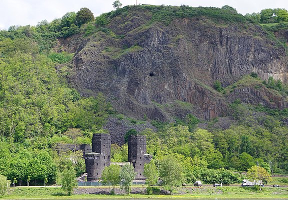
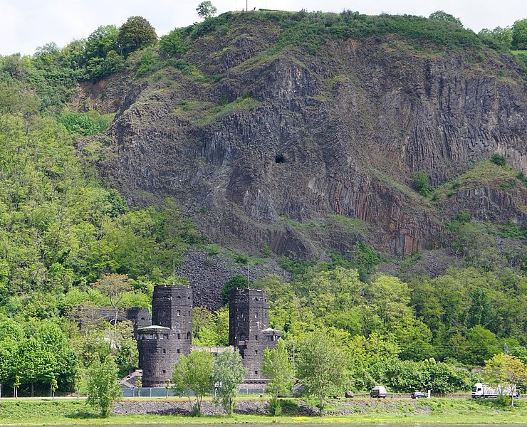
From the ferry, we walk upstream along the Rhine to the Remagen bridge. On the ramp, we avoid bicycle traffic and enjoy the view of the Erpeler Ley.
- Geological Highlight I
About 45 million years ago, the Eurasian and African continental plates moved towards each other. This began the Alpine folding and the uplift of the Central Uplands (endogenous forces). One result of the uplift was the formation of cracks in the Earth's outer crust, through which molten rocks (mineral melts = magma, lava) reached the Earth's surface.
The Erpeler Ley is part of the tertiary volcanoes. At its steep cliff to the Rhine, we see the volcanic pipe where lava cooled and contracted slowly just below the Earth's surface. Cracks in a honeycomb pattern opened. Basalt columns formed. On the one hand, the lava cooled from above; on the other hand, also from the side of the uplifted volcanic cone. Thus, columns grew from above and from the side. In addition, thinner columns formed near the surface than at deeper levels. These discontinuities can be seen at the Erpeler Ley. Vertically standing thick columns that cooled slowly are overlain by thinner, obliquely standing columns. Truly an impressive testimony to volcanism in the Rhenish Slate Mountains.
We leave the towpath and walk on farm roads past the stadium and swimming pool into the open fields of the Golden Mile up to the fenced water protection area.
- Geological Highlight II
About 1.7 million years ago, the uplift of the Rhenish Massif began and continues today by approximately 250 m, of which 190 m are within the last 700,000 years. The Rhine was able to carve itself deeply due to a deep-reaching fault in the Earth's interior at exactly this location. The terraces in the Rhine valley are a consequence of erosion and multiple smaller ice ages. During thaw periods, large amounts of water flowed carrying gravel and rubble, which on the one hand smoothed the underlying rock and on the other hand deposited as terraces. The so-called main terrace, on which the primeval Rhine flowed, lies about 150 m above today's Rhine. Especially in Remagen, the middle terraces, lower terraces, and river terraces below the main terrace are well developed, also because of the wider Rhine valley at this point. The areas flooded only during high water belong to the island terrace. We stand here on the lower lower terrace. Next to us, the basin belongs to the high floodbed of the Rhine, the island terrace, and the gentle rise behind it to the upper lower terrace. The Apollinariskirche is located on the middle terrace.
The route continues straight to Kripp to the Rhine ferry, with which we cross to Linz. Past Linz castle, we come to the Rhine Heights Trail, which we follow steeply uphill to two benches on the left side of the path.
- Geological Highlight III
During Earth's history, ice ages lasting up to 300 million years have occurred periodically. Today we have been in an ice age for 2.6 million years, the Quaternary period. Within the ice age, there are recurring climate fluctuations lasting between 10,000 and 100,000 years with warm and cold periods.
Associated with the climate fluctuations were periods of very sparse vegetation during which wind erosion led to strong dispersal of loose material. High loess deposits accumulated in front of and behind the topographical elevations, including on the slopes of the Rhine valley. We are standing on such a loess deposit here.
Shortly behind Ockenfels castle, we reach a large meadow offering a beautiful view over the Rhine Valley and the Golden Mile. Incidentally, a suitable place to have your packed lunch.
- Geological Highlight IV
Almost exactly towards the south, we see the prominent volcanic mountains of the East Eifel volcanic field around Laacher See. Orienting oneself by the transmitter Gänsehals (575 m), 20 km away, one sees just east of it the roughly equally distant volcanoes Laacher Kopf (443 m), Veitskopf (428 m), Krufter Ofen (463 m), Heidekopf (428 m) and the easternmost Laacher See volcano above 400 m, the Hummerich (425 m). The Laacher See volcanism belongs to the Rhenish Slate Mountains together with the West Eifel volcanic field.
Under the Eifel lies a large magma chamber (Eifel plume) rising from the deeper layers at depths of 60 km to 120 km, which regularly leads to measurable seismic activity (micro-earthquakes) in the Laacher See area.
We now follow the Rheinsteig further to the Erpeler Ley. At the Zeppelin monument, we have an excellent view of the Rhine course, the Golden Mile, and the Eifel mountains.
- Geological Highlight V
We stand here on the plateau of the Erpeler Ley, a plateau that the primeval Rhine has completely smoothed flat. On the opposite side of the Rhine, we can also clearly observe the broad primeval Rhine valley up to the rising heights of the Eifel.
Volcanism in the Tertiary began about 45 million years ago. The visible Eifel heights in front of us belong to the tertiary volcanoes. Only 14 km away, west of the Gänsehals transmitter, we see Olbrück castle standing at 470 m and distinctly rising above the horizon. To the right in the foreground is the Landskrone, nearly 3 km away and 272 m high; in the background, 18 km away the 668 m high Schöneberg transmitter; and again in the foreground, nearly 6 km away, the 340 m high Neuenahrer Berg. All are volcanic mountains from the Tertiary period.
Continuing along the plateau edge, we walk to the wooden cross. Here we look over the Rhine stream in front of us and the town of Remagen. Downstream, we can follow the Rhine to the Siebengebirge. The descent to Erpel leads over steep paths to the edge of town. Then across the Erpel market square to the passenger ferry to Remagen.
Once arriving in Remagen, tired from hiking and processing the many impressions, you can visit one of the many eateries in town or directly by the Rhine.
- Theme trail
- Hiking trail
- Hiking

source
Mittelrhein
·
Author:
Tourist-Information Remagen
















